
![A color cityscape 3D printed directly from Google Earth data [Source: Reddit]](https://fabbaloo.com/wp-content/uploads/2020/05/cityprintov_result_img_5eb0a98390af6.jpg)
Some folks found a way to 3D print full color cityscapes directly from Google Earth.
Google Earth is a fantastic free resource provided by, of course, Google. The system has somehow obtained 3D scans of vast areas of our planet, including most major cities. With Google Earth you can almost literally fly through cities, swooping between skyscrapers and zoom into fine detail on a street.
If only there were a way to access those digital 3D scans for 3D printing.
It turns out that there really isn’t a proper way for Google Earth to provide an API to get at that data, so it’s kind of “in jail” on Google.
But then, Reddit contributor “amishrefugee” posted this:
Coworkers and I figured out how to make full-color powder prints of chunks of Google Earth.
Aha! Perhaps they’ve discovered a secret digital access point into the Google Earth data?
No.
What they did was far simpler, and ridiculously ingenious: they used photogrammetry.
Photogrammetry is a method of 3D scanning in which optical images of a subject are captured from different angles. By examining the motion of the background between images, it’s possible for a specialized software system to gradually develop a 3D point cloud – and subsequent 3D model – from the images.
These folks simply used Google Earth’s views as if they had been operating a drone in the vicinity by positioning the view in a circular pattern around a target cityscape area. The resulting images were fed into a common photogrammetry tool and converted into a 3D model, as per the usual practice.
![Still image used for photogrammetry obtained from Google Earth - excellent detail! [Source: Reddit]](https://fabbaloo.com/wp-content/uploads/2020/05/image-asset_img_5eb0a983d8203.jpg)
The key here is that Google’s 3D captures are sometimes exceptionally detailed. In some cases they are almost photographic in quality, as seen here by one of the still images captured by the team:
I encourage you to download Google Earth – a free download – and try browsing your own city. You may be surprised at the level of detail they provide.
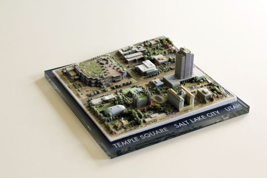
Once the 3D model was capture – and by the way it is a full color 3D model, since that is what Google Earth stores – they were able to 3D print the results on a (for them) handy full color 3D printer.
![View of 3D printed cityscape from Google Earth data [Source: Reddit]](https://fabbaloo.com/wp-content/uploads/2020/05/image-asset_img_5eb0a9841a9f7.jpg)
The results are quite good and equal to what one might have paid a professional a significant sum for an equivalent scanning and printing project.
There really isn’t a lot that Google can do about this, because they are simply using normal views of the surface from Google Earth.
![Not the greatest detail on this frame from Google Earth [Source: Google]](https://fabbaloo.com/wp-content/uploads/2020/05/image-asset_img_5eb0a9845d235.jpg)
Sometimes the view from Google Earth isn’t as perfect, as seen here in this closeup downtown image. Note the craggy lines on some of the buildings and streetlights. However, you simply back out until your image looks appropriate and then capture a bigger area for the 3D model.
Also note that there is a “Google Earth” logo in the bottom right corner. Advice: don’t include that in your photogrammetry analysis, or you may have silly results.
Enjoy!
Via Reddit